Date: 2/7/2024
Trip leader: Bruce Stafford
Party: Adrian, Ania, Grace, Wentao
Walk in Mount Victoria area; Tuesday 2nd July 2024.
This walk was intended as a relatively easy walk to Blair Athol Mine, and then to Mt Piddington. It turned out to be anything but. Read on.
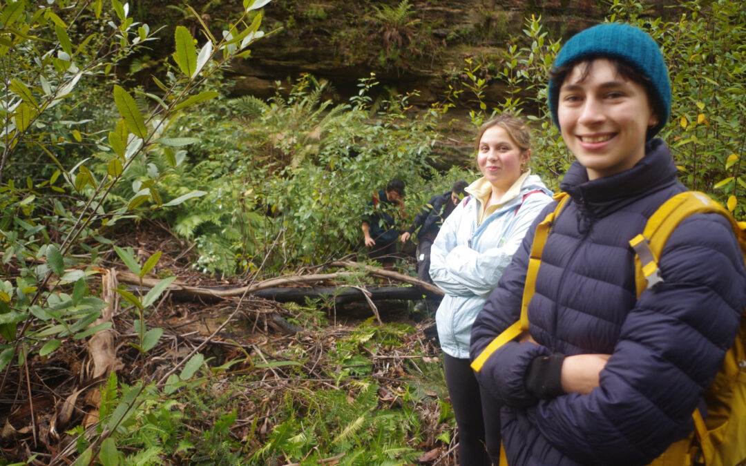
Four of us met up at Central for the Lithgow train, which being a normal weekday was unusual in stopping at only four stations along the way, so it took only 2 hours to get to Mount Victoria. Along the way we saw the bat colony at Clyde, now also being invaded by Ibis (“bin chickens”), and Ania thought that the bats looked like black plastic shopping bags hanging from the branches. No Kangaroos were seen in the grounds of UWS Werrington this time.
On arrival at Katoomba the town was shrouded in a thick fog so the tourists getting off the train there would not have seen much. After Blackheath though the fog lifted to give sweeping views from the train of the Kanimbla Valley to the south. At Mount Victoria it was a windy 5 degree Celcius, but no sign of any rain (at this stage). Adrian was waiting for us there.
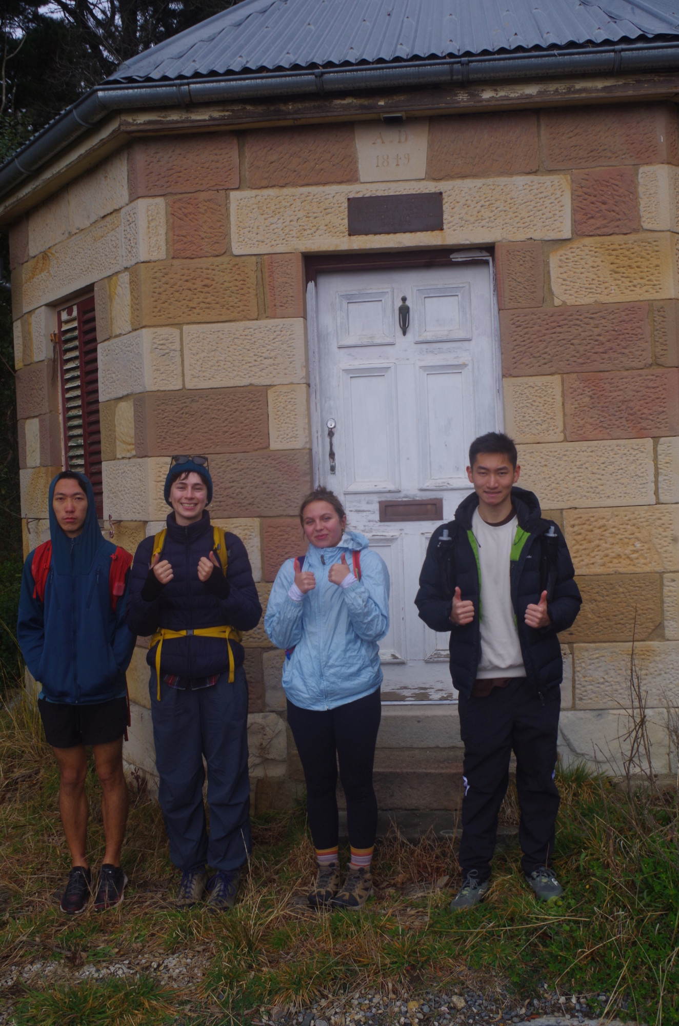
Then we headed for the Great Western Highway, passing by an old toll house (yes the road had tolls even then) and has the date “1849” as per the first photo. We had to re-cross the busy highway to get to Victoria Falls Road, because (as yet) there is no footpath on the opposite side and the verge there is very narrow.
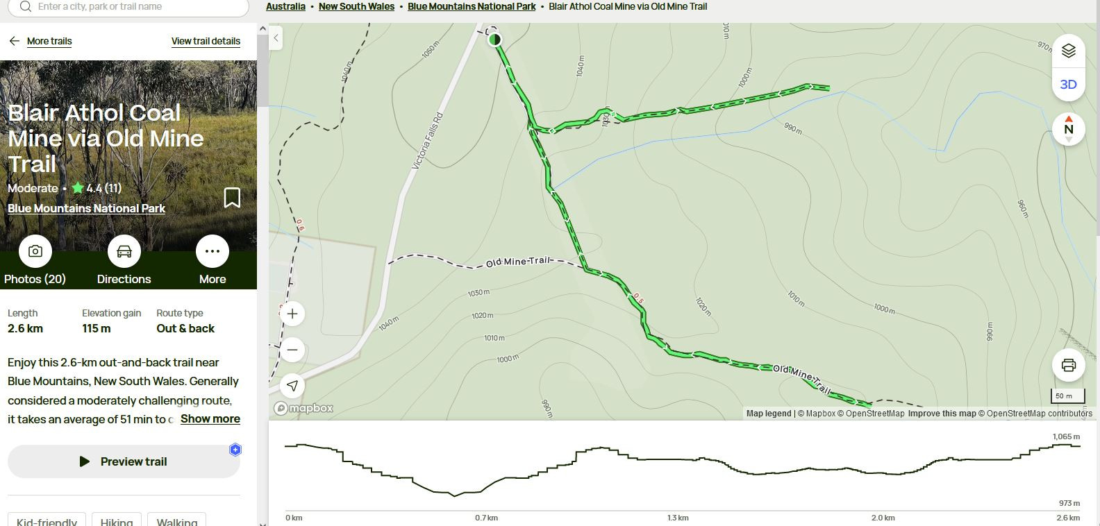
Once across we set off on a walk of about 500 metres along Victoria Falls Road to the track marked “Old Mine Trail” on the “Alltrails” description of this walk (see relevant photo). I will have more to say about this Alltrails guide further on. The track called “Old Mine Trail” is an old fire trail and after about 350 metres intersects the trail that follows the high tension power lines. From there it goes for another 600m or so until reaching a cleared area which looks like it has occasionally been used as a camp site. From this point however there were no obvious tracks leading on anywhere, but Jin decided to go ahead and see what could be found as we started descending down a slope. At first it was no trouble but soon the vegetation got thicker and thicker and the slope steeper. Now, it is a good bushwalking rule of thumb that if something does not look right, it probably isn’t! Be guided by your instincts. I was having doubts that this was the right way to the mine, but Jin going ahead had reached the creek at the bottom (Victoria Brook) and was starting to head downstream to where the approximate location of the Mine should be.
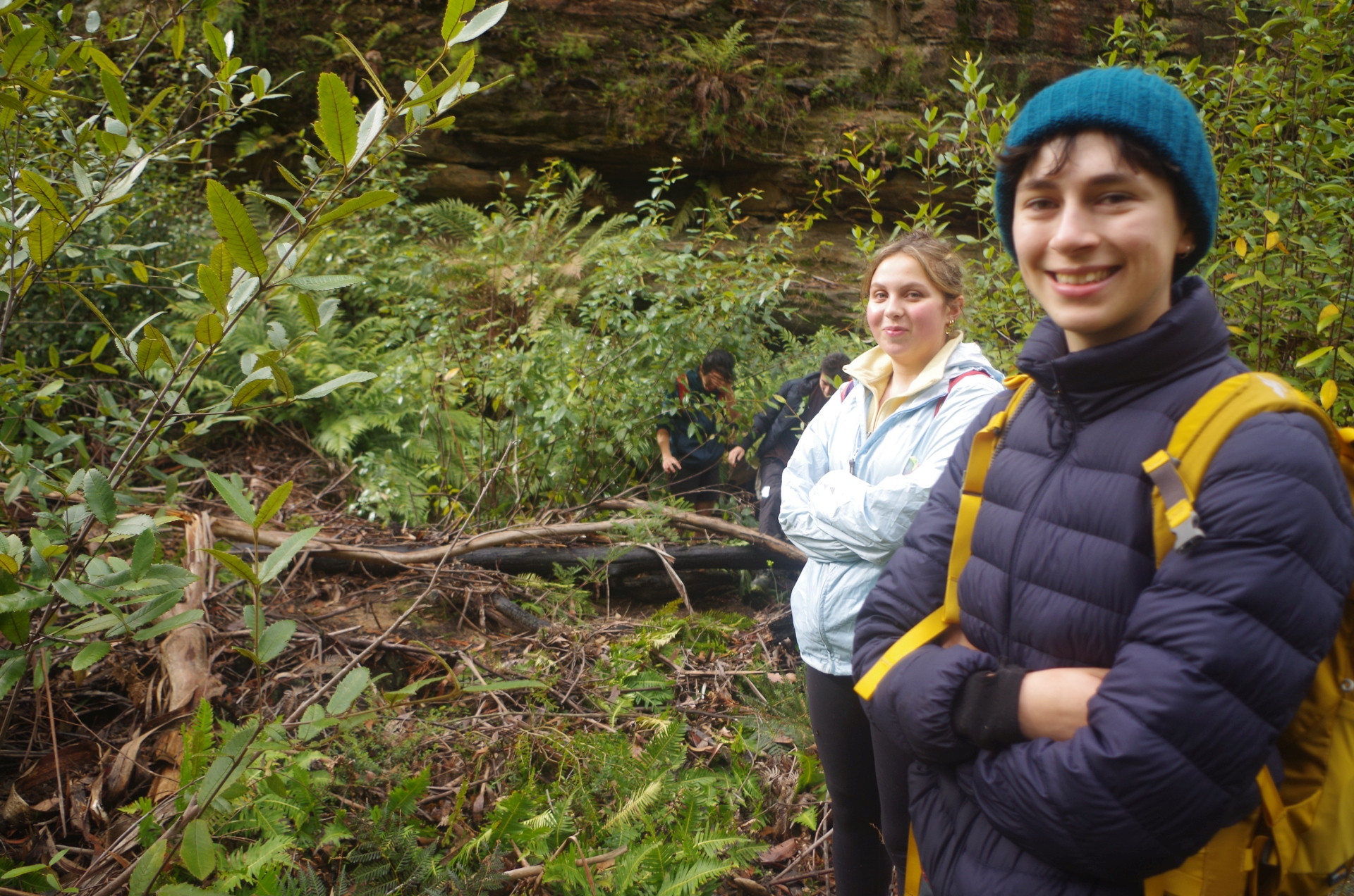
To get an idea of what the condition of the “way” following the creek was like, photo 2 partly helps. This area and the Grose Valley nearby were severely burnt in the great bushfires of the summer of 2019-2020, and there was evidence of this everywhere in the form of burnt fallen tree trunks and large branches which impeded progress at several places. Not only that, but those bushfires were followed by wet summers and flooding rain, and there’s evidence of that too; plenty of small branches and other debris washed down and piled up in a couple of places. Most important was that there had been prolific plant growth thanks to the wet summers, and it was very thick and tall along the banks of the creek; if someone got just 5 metres ahead they could not be seen! None of this seemed to worry Jin though who seems to love bush-bashing and scrambling, and he kept going ahead.
(Ashley Burke, one of SUBW’s experienced long-time members, warns of expecting similar tough conditions in the Southern Blue Mountains after the big fires there: http://ashleyeylenburg.com//3Peaks/index.htm#OtherChallenges ).
At one point we had to do one of our several creek crossings but I decided that it was easier to simply walk in the water along the creek bed rather than get through the tangle of vegetation. So relying on my thick woolen socks and the boots that Joe gave me at the recent AGM, I just stepped into the water. The woolen socks meant that my feet didn’t feel cold at any time even later in the day. Indeed, despite the cold temperature which stayed at around 7C, we didn’t feel cold much at any time. We were also very fortunate to have only two very brief rain showers whixh lasted only a minute or so.
Soon it was time for lunch and we found a relatively flat section which some rocks that could be used for seats, and had a fairly brief lunch break of about 20 minutes. I worked out that we had taken one hour to cover 200 metres of the creek. Jin wanted to continue following the creek at this level, which had slightly less dense vegetation than lower down, but it was still an estimated hour and a half in these conditions to get to where the mine was. As it was nearly 2pm by now, I decided that we couldn’t keep doing that and would have to make our way up and out of the the creek valley and back to the trail that we had left some 2 hours earlier. It was just too risky to continue any further especially as time was getting on and because of the overcast skies it would start getting dark early. Rain radar also showed a rain band arriving in less than an hour as well. Not only that, but we had a deadline to get back to Mount Victoria Station, the 4pm train. The next train was 2 hours later at 6pm, which wouldn’t get us back to Sydney until 8.20pm, getting too late for some who had to go further on to get home.
The lay of the land indicated that a short scramble uphill to the south would take us to a less steep area which would then take us up and out. Jin hadn’t oriented the map on his phone to north so I got him to do that, observed where the sun was, got my own iPhone to show the compass, and worked out that a compass heading due south with the sun at NNW would do the trick. So off we went, relying on some old-fashioned navigation. At one point Jin got way ahead so that even in the now thinner vegetation we could not see him, so I yelled out to him to slow down. He thought that I was asking him to “go down” (i.e., start going downhill again), but I corrected that when we caught up to him. Heading on the same bearing we got back to the end of the old trail where we had started the bush bash.
From there we walked back to where the trail under the high tension lines intersected this track, and Jin said that if we turned right and followed this powerline track, it would lead to where the real track to the mine should start. The “track” just shows as a line on dots on his phone map, which made me skeptical about it being a proper track, but as this powerline track still took us back to Victoria Falls Road, we were not going to get lost or lose that much time, so we gave it a go. It went down into a gully and then back out again until reaching a locked gate, and beside this locked gate was a side track with a NPWS signpost stating it was the track to Blair Athol Mine! It stated it was a 30 minute walk. Jin wanted us to take the track but as it was about 2.45pm by then, a return walk along that track would cause us to miss the 4pm train (NPWS times tend to be conservative but even so their 30 minutes each way time estimate didn’t include looking around the area and going inside the mine which is 200 metres long). Jin then said that he and Adrian could run there and back and should still be able to get the train in time. So, given that there was no risk now of them getting lost, they did that while Grace, Ania and myself headed back along Victoria Falls Road to the main highway. We did not encounter a single vehicle on Victoria Falls Road, very few tourists are around there on a weekday.
Traffic was starting to get heavy by now on the highway, and was dicey crossing it at the Victoria Falls Road junction,so we elected to use the traffic lights at Station Street when it came to cross it later at the shops. Now, there is a traffic camera at the highway here, which renews its images on the “Live Traffic” app every minute, so I was able to show ourselves appearing briefly on the app on my mobile phone! We arrrived at the Station 30 minutes before the train was due, and had a welcome loo stop before heading to the warm waiting room. Shortly after, Jin and Adrian arrived. The train left at 4.01pm and got back to Sydney ay 6.20pm, although Adrian got off at Parramatta and I got off at Strathfield.
Despite the setbacks and not completing the originally proposed destinations, the trip worked out fairly well and we all learned something from it, and it was a refresher in navigation skills! We all managed fairly well given the conditions which Ania described as “hard-core bushwalking”.
Some important takeaways to this walk: First, I have in the past expressed my skepticism about “hikes” posted on some websites such as “Alltrails”, and this trip has increased my skepticism. If you have a look at the map accompanying this “hike” it shows that whoever charted it went at first to the correct mine, and THEN backtracked to walk along the trail marked “Old Mine Trail” to its end and then back again. Why they did this is not clear, but it does give the impression that Blair Athol Mine is located near the end of the second longer track, which is wrong. Both Alltrails and Google Maps label that second longer track as “Old Mine Trail”; the 1:25000 Mount Wilson topographic map shows both tracks but does not name them. (If you go to the Alltrails website for this “hike” it is interactive so you will see what I mean. I also use the word “hikes” here instead of “bushwalk” as “Alltrails” is a U.S. based website).
This was the first – and last – time that I will rely on “Alltrails”.
Second, there will be occasions when the trip leader will have to terminate a walk before reaching the destination if conditions make it too risky or too late to continue on. We organise bushwalks, not guided tours, and unexpected things can happen. (Some new members in past years did think SUBW is a guided tours company; one actually asked where the SUBW “office” was). Related to that is this: if there were a significant numbers of freshers on this walk, I would have turned it around before getting into thick scrub and hard conditions. Adrian is a newer member and managed the conditions very well, but others with zero understanding of the Bush would have been dismayed (Ania assured Adrian that not all walks are like this!). Grace and Ania took the econditions in their stride no problem.
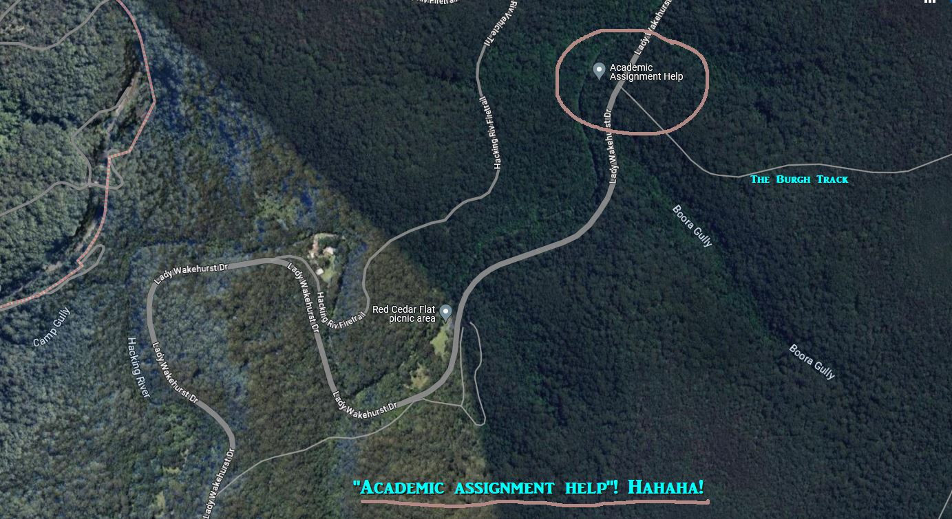
The inaccuracy of some on-line maps is also an issue. Take a look at the last screen shot pic I took of a location on Lady Wakehurst Drive and The Burgh Track at Otford. Note the place called “Academic Assignment Help“. I’m not sure if this is the result of a wrong entry of co-ordinates, or is someone’s idea of a joke, but it is no joke. I can imagine an overseas student asking a Uber driver to take them to “Academic Assignment Help”, the Uber driver keys it in to their GPS, and drops the student off in very thick bushland to manage for themselves there (a TAXI driver would say “what?, there’s nothing there except leeches”). I’m not sure of the process to get Google to get rid of this, but if any of you know, give it a try.
One more thing, this might be an interesting place for an exploratory walk and testing navigation skills when the weather is warmer and days longer, but there’s another problem: when the weather warms up this is classic Tiger Snake country!
Only a couple of pics this time. I will better next time!
Bruce Stafford.